By E. Patrick Neer | Echo
Losing your keys is an inconvenience. Losing a 200-foot-long, 660,000-pound aircraft plane? That's something else entirely.
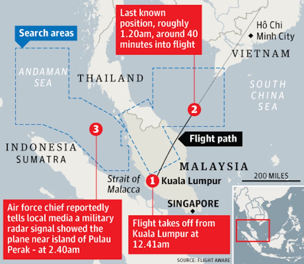
Malaysian Airlines flight MH730 launched from Kuala Lumpur last Saturday, en route for its destination in Beijing. Forty minutes passed uneventfully, with Malaysian radar tracking the progress of the flight to the edge of its range, midway across the Gulf of Thailand. Malaysian air traffic control notified the pilot that he was to prepare for the handoff to Ho Chi Minh City air traffic control. The pilot responded with "All right, good night."Malaysian authorities assert this was the last contact with flight MH730, ABC News reported. Flight MH730 carried 239 passengers and crew, two-thirds of whom were Chinese.
The flight's disappearance prompted a week of frantic searches by the governments of 10 nations. The search has covered a total of 35,800 square miles in the South China Sea to the east of Malaysia and the Andaman Sea to the west.
The searches have been characterized by a glut of contradictory information.
Satellite images released yesterday by China's State Administration for Science, Technology, and Industry for National Defense show what could be pieces of the crashed aircraft, the Associated Press reported. The images, taken a day after Flight MH730's disappearance, show white objects presumed to be plane wreckage floating in the water of the South China Sea off the southern tip of Vietnam.
These pictures come at odds with reports from the Malay deputy transport minister, Pham Quy Tieu, who has claimed that the area photographed in the Chinese images has been "searched thoroughly," according to Huffington Post.
U.S. counterterrorism officials are still pursuing the possibility that the plane was intentionally diverted after turning off the plane's transponders to avoid radar detection. Although evidence for terrorist activity or sabotage has not been confirmed, neither have been ruled out, according to The Wall Street Journal.
According to the data transmitted by the aircraft engine, U.S. national security officials believe the plane stayed in the air about four hours after it disappeared from radar. However, it still remains unclear whether the plane reached an alternate destination-or if it crashed, possibly hundreds of miles from the current search radius.
Malaysian authorities, in contrast, claim to have received a signal on the southern perimeter of their radar, a signal that has led the search effort to expand its range south and west towards the Straits of Malacca, The Guardian reports. These authorities quickly dismissed the Wall Street Journal report, according to Al-Jazeera."As Malaysia Airlines will confirm shortly, those reports are inaccurate," said Transport Minister Hishammuddin Hussein.
In America, one company has adopted a different approach to the investigations.
DigitalGlobe, a Colorado-based commercial satellite firm, has taken the search for Flight MH730 to the masses, CNN reported. As satellites owned by DigitalGlobe pass over Southeast Asia, captured images are posted on the DigitalGlobe crisis website. Online volunteers are encouraged to comb these images for any signs of the fate of Flight MH730, whether it be life rafts or wreckage.
The endeavor proved so popular that Tomnod, DigitalGlobe's crisis response website, buckled under increased traffic. It logged 500,000 unique visitors in the first day alone, the Denver Post reported.
"DigitalGlobe is doing all of this work for free, just like the Tomnod users are doing this for free," said Luke Barrington, senior manager of geospatial data at DigitalGlobe.
"That's all part of our vision of seeing a better world."(Thumbnail graphic courtesy of The Guardian)